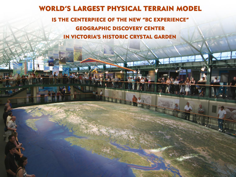
On this episode of How it's Made: Sanders; 3D Solid Terrain Models; Stucco; Roll-up Doors.
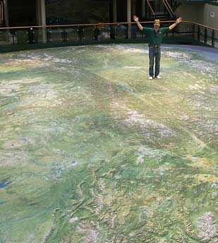
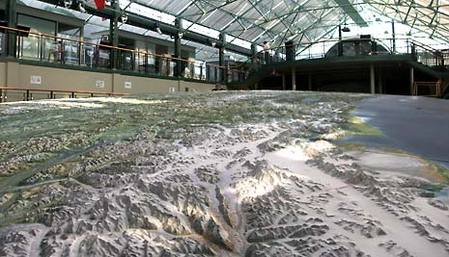
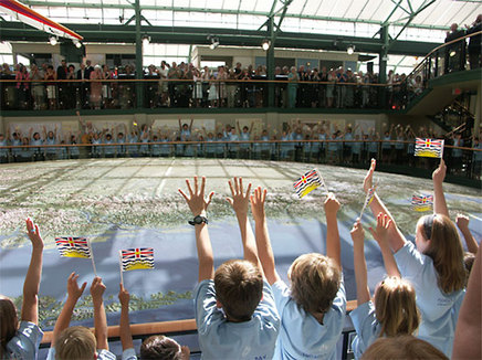
See how the huge map models, terrain models, topographic models and 3D models are made in some time by Solid Terrain Models. Also see World's largest physical terrain model of British Columbia in Victoria's historic crystal garden.
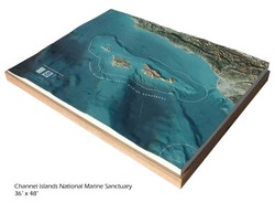
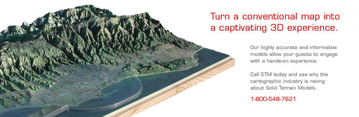
3D terrain map of BC by STM-USA
Turn on your TV and see Discovery Science channel at 9:00 PM on 21st Novmeber 2013. Repeat telecast will be available at 12:00 AM on 22nd November 2013, at 4:00 AM on 23rd November 2013, at 7:30 PM on 30th November 2013 and at 2:30 AM on December 1st 2013.
Check this link for live telecast : http://science.discovery.com/tv-shows/how-its-made/tv-schedule.htm
Printing technology has certainly come a long way. In the olden days, people could not even print mass amounts of material. Instead they had to be hand copied. Then the printing press was invented and printed material became more accessible. Today, we have printers in our homes and offices and with the click of a button, we can print of pages and pages of material if we wanted. Now, the newest generation of printers has arrived: the 3D printer. What once was a pipe dream (like the original printer) is now a reality and soon every home will have a 3D printer. Of course, today’s 3D printers are still a long way off from printing an exact, working replica of real life objects. Instead, these printers use a special plastic substance that hardens and forms a 3D object.
"Inkjet printing on 3D objects" (check out here) also make it possible to have different prints and designs on objects. So, why is this important? Well, aside for being a gateway technology, many firms can already benefit from this relatively simple device. For example, design firms can create their own models in house and make prototypes cheaply, which means products can hit the market faster. This would make smaller firms more competitive as they can afford to make prototypes cheaper and faster and with Solid Terrain Modeling INC inkjet printing on 3D objects, they can make them look more realistic. competition can benefit consumers, as products become more innovative, and maybe cheaper. Although we may be far off from printing household objects directly, soon, if you needed a specific tool like a screwdriver or barbecue tongs, you won’t have to run to the store, but make it yourself instead.
 Sand table is a term for utilizing constrained sand for educational or modeling purposes. Sand tables are usually utilized for military planning and war gaming for so many field years in map small scale and military training actions. The use of sand table cut down progressively because of the used of advanced satellite photographs, digital land stimulations and maps and aerial. Nowadays, virtual and conventional sand tables are often used for training operations. Using military sand table can be operation, tactical or strategic military planning, training and familiarization. It can improve the visual understanding of river deltas, desert regions, mountain ranges and urban areas. Warfare has become digital in today’s contemporary world. Nowadays, the military utilizes all the technology at its disposal to carry out their strategies and missions. Many airplanes nowadays, for example, feature modern navigation systems, steering and weapons. However, that does not mean that old school materials and strategies are not being used anymore. In many instances, low technology is still useful. When out in the field, for example, it is not always practical to carry along wide screen TV’s and computers. Thus, many commanding officers make use of a military sand table and drawings to explain to their team what to execute. Additionally, sand tables deal with various abilities and encourage various senses for children at young ages. This concrete, beneficial educational tool enables the child to control and explore various materials placed in the table. A sand table can also develop your child’s fine motor abilities that will improve his scientific understanding and imagination.
In today’s modern world, we have access to so much information about the world today. At the touch of a button we can get our hands on whole libraries and get the information we need. One thing that is quite useful today that we all use is a map. Can you imagine what like was like when we couldn’t just look up that hot new restaurant or the theater on our computers or smart phones? It’s a wonder we didn’t get lost all the time! One type of map that we may not think is very useful are terrain maps. Sure, it’s cool to look at mountains and rivers, but what do we use it for? If you’re driving around or navigating a new city, you most probably want a street map. However, don’t discount these terrain maps. They are quite useful in many ways.
Terrain maps
First, people who do a lot of hiking or going on trails can really use these types of maps. Often there aren’t very many online maps of trails, or sometimes most adventurers don’t really use any trails. In such cases, a terrain map is really useful. Hikers can plan out their routes since they know what to expect when it comes to the terrain they are hiking. Using these maps, they can map out the dangers and pitfalls they should avoid and which parts are safe to camp at. Next, they can be useful for educational purposes. Students can use them to learn about the different types of terrain today.
Terrain maps are accurate and detailed two-dimensional representation of human made and natural features on the surface of the Earth. These maps are used for various applications like hunting, fishing, camping and hiking to resource management, surveying and urban planning. The most unique feature of a terrain map is that three dimensional shape of the Earth’s surface is made by contour lines. Contours are unreal lines that connect locations of the same surface.
Terrain Maps
Terrain map usually use various symbols to describe both human made and natural features such as quarries, buildings, roads, vegetation, lakes and streams. Terrain maps used symbols that represent human constructed and natural features found in the nature or environment. The symbols are used to represent features in three common types such as polygons, lines and points. Points are used to show features like buildings and bridges. Lines are used to illustrate linear features.
Terrain map
Usually, some features include railways, rivers and roads. You may recognize that some maps are using different symbols to illustrate a feature. Nevertheless, you can find different types of maps on the internet. They can help you understand the Earth’s surface with a more realistic appearance that can help you identify the details easily.
Terrain maps
When you buy for a terrain board it is important to consider your height. If the board is very long your posture will be very wide and it may cause difficulty in your balance and control. If the board is too small for your feet, it can be close jointly and you can have a trouble in balancing because the board will be unstable. You should also consider the weight of the board. Lighter boards can be expensive due to materials and technologies used. Do not rush your purchase, preferably find a reliable provider of terrain board for your money’s worth.
|

 RSS Feed